
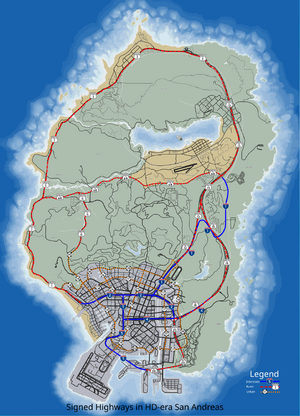
Map of HD-era San Andreas Numbered Highways
Grand Theft Auto V introduces a new complex transportation network of various different numbered highways in San Andreas (also called routes or freeways), which are a system of interconnecting roads and highways that crisscross the state of San Andreas. Routes usually consist of only two lane roads with multi-lane roads and freeways in some sections. Grand Theft Auto V has the most realistic and extensive freeway system of any other GTA game to date. Some of these routes are based on the leaked official GTA V map, which included route markers, while others are signed in the game itself.
The system is based on the real-life numbering system in the United States, but with some differences. Rural major routes (such as Routes 1 and 13) are signed with U.S. Route shields, while minor urban routes (such as Routes 14 and 17) are marked on freeway guide signs with generic state highway markers, which are also used in real life for the state highway markers in Delaware, Iowa, Kentucky, Mississippi, and New Jersey. The interstate system almost always consists of multi-lane freeways and are usually traveled on more than the Routes.
Route Markers
")
")
")
Interstate Highway System
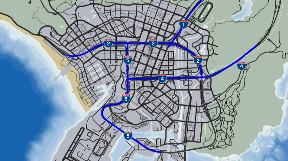
The Interstate System, officially the Dwight D. Eisenhower National System of Interstate and Defense Highways in real life, is a network of highways in the state of San Andreas that circulates the Los Santos metropolitan area before ending or merging into other roads. There are four Interstate highways: Los Santos Freeway, Del Perro Freeway, Olympic Freeway, and the La Puerta Freeway.
The highway names begin with an "I" prefix and then a number directly after a dash (i.e. I-4). The system exists of four highways, however, I-3 is absent in the game. Along with the highways, Grand Theft Auto V has the most extensive freeway system in a Grand Theft Auto game.
List of Routes
Interstate

Interstate Highways in the Los Santos area.
- Interstate 1 - Los Santos Freeway
- Interstate 2 - Del Perro Freeway
- Interstate 4 - Olympic Freeway
- Interstate 5 - La Puerta Freeway
Rural (US Routes)
- Route 1 - Great Ocean Highway
- Route 11 - Tongva Drive
- Route 13 - Senora Freeway
- Route 15 - Palomino Freeway
- Route 20 - Elysian Fields Freeway
- Route 68
- Route 23 - Del Perro Freeway
Urban (State Routes)
- Route 14 - North Rockford Drive
- Route 16 - Mad Wayne Thunder Drive
- Route 17 - Popular Street
- Route 18 - Vinewood Boulevard
- Route 19 - Alta Street
- Route 22 - Dutch London St
Trivia
- The arrangements of the number of the interstates is opposite to real-life counterparts. As for even-numbered ones, the number increases from north to south (For example, Interstate 2 is located in the north of Interstate 4), but in real-life it should be from south to north (Real-life I-8 is in the south of I-10). For odd-number ones the number goes increasing from east to west (see Interstate 1 and Interstate 5), as in real-life it will be from west to east. The rural routes is much the same, with US 68 north of US 20, and US 15 east of US 13 -- all of which opposite to real-life numbering rules. However, for state routes there is no such rules, and it's the same to the real-life California State Routes.