No edit summary |
No edit summary |
||
| Line 6: | Line 6: | ||
{{GTA V road/marker|US|15}} - [[Tataviam Mountains]] |
{{GTA V road/marker|US|15}} - [[Tataviam Mountains]] |
||
|north end={{GTA V road/marker|US|13}} and {{GTA V road/marker|US|68}} near [[Davis Quartz]] |
|north end={{GTA V road/marker|US|13}} and {{GTA V road/marker|US|68}} near [[Davis Quartz]] |
||
| + | |other names=[[Los Santos Freeway (GTA V)|Los Santos Freeway]] |
||
| − | |exits= |
||
| ⚫ | |||
| ⚫ | |||
| ⚫ | |||
| + | |||
| ⚫ | |||
| ⚫ | Interstate 1 begins from the south on Strawberry Avenue, at the intersection with the [[Del Perro Freeway]] in [[East Vinewood]] and [[Strawberry Ave]]. It begins as the [[Los Santos Freeway]], a six-lane urban freeway traveling northeast, intersecting the [[Vinewood Racetrack]] and the [[Vinewood Bowl]]. It then begins to turn north while narrowing to a rural four-lane freeway at the [[Route 18]] interchange, and skirts along the western edge of the [[Tataviam Mountains]]. This part is co-signed with [[Route 13]]. |
||
| + | |||
| ⚫ | [[File:Interstate_1_Senora_Way.jpg|thumb|Exit Sign to Senora Way]]At the intersection of the [[Palomino Freeway]], the two routes split with 13 continuing north as the [[Senora Freeway]] and I-1 (according to the exit guide signs) turning toward [[Route 15]]. As soon as it goes onto the Palomino, it immediately exits onto [[Senora Way]]. Unusual for an Interstate, it continues as a two-lane road until it ends at the intersection of Route 13 and [[Route 68]]. The only sign that indicates I-1 being on Senora Way is an exit sign on the Palomino Freeway. |
||
| + | |||
| + | ==Intersections== |
||
| ⚫ | |||
<tr> |
<tr> |
||
| + | <th>Location</th> |
||
| + | <th></th> |
||
| + | <th>Destination</th> |
||
| ⚫ | |||
| + | <tr> |
||
| + | <td>[[Pillbox Hill]] |
||
<td>[[File:I-start.png|16px]]</td> |
<td>[[File:I-start.png|16px]]</td> |
||
| − | <td> |
+ | <td>[[Strawberry Ave]] (road continues)</td> |
| + | </tr> |
||
| + | <td>[[Alta]]</td> |
||
| + | <td>[[File:I-exit.png|16px]]</td> |
||
| + | <td>{{GTA V road/marker|I|2}} and {{GTA V road/marker|SA|17}} (s/b)</td> |
||
</tr> |
</tr> |
||
<tr> |
<tr> |
||
| + | <td>[[East Vinewood]] |
||
<td>[[File:I-exit.png|16px]]</td> |
<td>[[File:I-exit.png|16px]]</td> |
||
<td>{{GTA V road/marker|SA|18}}</td> |
<td>{{GTA V road/marker|SA|18}}</td> |
||
| Line 18: | Line 38: | ||
<tr> |
<tr> |
||
<tr> |
<tr> |
||
| + | <td rowspan="3">[[Tataviam Mountains]]</td> |
||
<td>[[File:I-exit.png|16px]]</td> |
<td>[[File:I-exit.png|16px]]</td> |
||
| − | <td> |
+ | <td>Frontage road (n/b)</td> |
</tr> |
</tr> |
||
<tr> |
<tr> |
||
<td>[[File:I-exit.png|16px]]</td> |
<td>[[File:I-exit.png|16px]]</td> |
||
| − | <td>{{GTA V road/marker|US|15}}</td> |
+ | <td>{{rmark|US|13}} and {{GTA V road/marker|US|15}} (begin concurrency)</td> |
</tr> |
</tr> |
||
<tr> |
<tr> |
||
<td>[[File:I-exit.png|16px]]</td> |
<td>[[File:I-exit.png|16px]]</td> |
||
| − | <td> |
+ | <td>Senora Way and {{rmark|US|15}} (end conurrency)</td> |
</tr> |
</tr> |
||
<tr> |
<tr> |
||
| + | <td>[[San Chianski Mountain Range]]</td> |
||
| ⚫ | |||
<td>[[File:I-end.png|16px]]</td> |
<td>[[File:I-end.png|16px]]</td> |
||
| − | <td>{{GTA V road/marker|US|13}} |
+ | <td>{{GTA V road/marker|US|13}} and {{GTA V road/marker|US|68}} (road continues)</td> |
</tr> |
</tr> |
||
</table> |
</table> |
||
| ⚫ | |||
| ⚫ | |||
| − | |||
| ⚫ | |||
| ⚫ | Interstate 1 begins from the south on Strawberry Avenue, at the intersection with the [[Del Perro Freeway]] in [[East Vinewood]] and [[Strawberry Ave]]. It begins as the [[Los Santos Freeway]], a six-lane urban freeway traveling northeast, intersecting the [[Vinewood Racetrack]] and the [[Vinewood Bowl]]. It then begins to turn north while narrowing to a rural four-lane freeway at the [[Route 18]] interchange, and skirts along the western edge of the [[Tataviam Mountains]]. This part is co-signed with [[Route 13]]. |
||
| − | |||
| ⚫ | [[File:Interstate_1_Senora_Way.jpg|thumb|Exit Sign to Senora Way]]At the intersection of the [[Palomino Freeway]], the two routes split with 13 continuing north as the [[Senora Freeway]] and I-1 (according to the exit guide signs) turning toward [[Route 15]]. As soon as it goes onto the Palomino, it immediately exits onto [[Senora Way]]. Unusual for an Interstate, it continues as a two-lane road until it ends at the intersection of Route 13 and [[Route 68]]. The only sign that indicates I-1 being on Senora Way is an exit sign on the Palomino Freeway. |
||
==Map== |
==Map== |
||
Revision as of 16:14, 18 January 2014
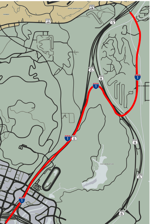
Template:GTA V road Interstate 1 is an Interstate highway in the eastern part of San Andreas. It connects the Grand Senora Desert to the Los Santos International Airport, via Strawberry Ave.
Route description
Interstate 1 begins from the south on Strawberry Avenue, at the intersection with the Del Perro Freeway in East Vinewood and Strawberry Ave. It begins as the Los Santos Freeway, a six-lane urban freeway traveling northeast, intersecting the Vinewood Racetrack and the Vinewood Bowl. It then begins to turn north while narrowing to a rural four-lane freeway at the Route 18 interchange, and skirts along the western edge of the Tataviam Mountains. This part is co-signed with Route 13.
Exit Sign to Senora Way
At the intersection of the Palomino Freeway, the two routes split with 13 continuing north as the Senora Freeway and I-1 (according to the exit guide signs) turning toward Route 15. As soon as it goes onto the Palomino, it immediately exits onto Senora Way. Unusual for an Interstate, it continues as a two-lane road until it ends at the intersection of Route 13 and Route 68. The only sign that indicates I-1 being on Senora Way is an exit sign on the Palomino Freeway.
Intersections
| Location | Destination | |
|---|---|---|
| Pillbox Hill | Strawberry Ave (road continues) | |
| Alta | and (s/b) | |
| East Vinewood | ||
| Tataviam Mountains | Frontage road (n/b) | |
| and (begin concurrency) | ||
| Senora Way and (end conurrency) | ||
| San Chianski Mountain Range | and (road continues) |
